Jump to content

Rip76

Legacy Members
  • Posts

    7989
  • Joined

  • Last visited

Everything posted by Rip76

  1. Lindner latest - TLDR 7-6-25 845am Update on the weather and rivers over the Hill Country and central Texas. No new flash flooding overnight Weather pattern remains in place today into Monday for additional heavy rainfall and flash flooding Persons should continue to be mindful of the weather conditions while visiting, camping, and vacationing in this area through tomorrow. The good news is that thus far there has been no new heavy rainfall and flash flooding, but recent radar trends west of I-35 suggest an increase in activity including pockets of heavy rainfall. Guidance continues to indicate the potential for additional isolated areas of excessive rainfall today, tonight, and into Monday over portions of the Hill Country and central Texas as the slow moving/stalled mid level trough axis/weakness aloft remains over this area combined with tropical moisture. As mentioned before, the where, when, and how much are the key questions in this type of setup and we are at the limit of the science on these answers usually until the storms begin to evolve. Where the heavy rain falls can quickly result in flash flooding on normally dry creeks and rivers…in some cases the water can rise feet in minutes yielding little time for action. Persons in vulnerable locations along dry or low flowing creeks and rivers must keep abreast of water levels and conditions and be prepared to react quickly. Rivers: Floodwaves have terminated into the various lakes in central Texas (Lakes Travis, Buchannan, and Canyon). These lakes remain well below normal conservation pools due to the long term drought in this area and will be able to fully absorb these flood flows with no downstream impacts or flood gates releases. It should be noted that higher than normal flows are occurring at several points in the Highland Lakes chain and significant debris has been washed into the various lakes in the last 48 hours making boating and recreational use hazardous at times. Rainfall below the control structures yesterday will result in rises on the Colorado River at Bastrop and Smithville today and the Guadelupe River downstream through Victoria this week. Based on current flows and forecasts no flooding is expected, but flows along the river will be elevated and normally dry low land areas will be inundated. Local: Rain chances will begin to increase over our local area into early this week in association of an upper level low that will approach from the northeast Gulf. This will usher in more favorable conditions for afternoon showers and thunderstorms along the seabreeze. Heavy rainfall will be possible as is typical in such summer situations with some isolated instances of street flooding through mid week. High pressure will attempt to build into the region later this week and lower rain chances, but how fast this happens is in question and thus far this summer significant high pressure has been unable to gain a strong foothold over the state or region and completely shut off rain chances. Summer patterns are hard to break once they become established given generally weak flow in the atmosphere this time of year. e
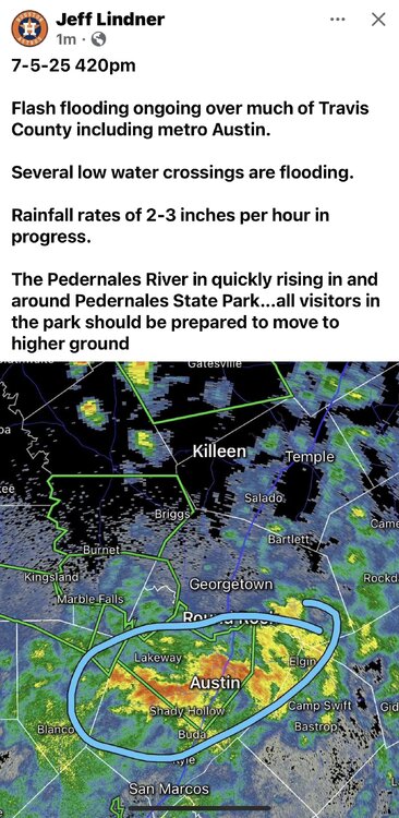
  2. Jeff Lindner- 7-5-25 800pm Summary of ongoing flooding, Lake levels, and forecast Flash flooding continues over portions of the I-35 corridor. While rainfall has weakened early this evening there remains the potential for isolated excessive rainfall again tonight across the Hill Country and I-35 corridor. Ongoing river flooding will NOT impact any portions of southeast Texas. Rivers: South Fork of the San Gabriel River: The headwaters of the river received 16-20 inches of rainfall overnight generating a catastrophic floodwave that moved downstream through Georgetown today. The river has crested and falling quickly back within banks, but numerous locations along the river have suffered extensive damage including several homes, RV recreational locations, and roadways. Catastrophic flash flooding over southern Burnet, NW Travis, and western Williamson Counties have resulted in at least 6 fatalities overnight and several persons are still missing. San Saba River: Extremely high flows on the San Saba River into the town of San Saba has resulted in extensive flooding. The river is starting to fall while the downstream floodwave enters the Colorado River and Lake Buchanan. Lake Buchanan will be able to store the incoming flood flows and no releases are expected. Highland Lakes and Lake Travis: High inflows from the Llano River into Lake LBJ and Marble Falls has resulted in floodgate operation by LCRA to pass flood flows through these lakes and downstream to Lake Travis. Due to inflows from upstream as well as the 10-16 inches of rain that fell near the northeast end of Lake Travis this morning a significant rise of 17ft in the lake pool over the last 24 hours has occurred. However Lake Travis is still well below its conservation pool and will be able to completely store all the incoming run-off without any floodgate operations and releases downstream. Guadelupe River: Catastrophic flooding along the Guadelupe River from upstream of Hunt TX to downstream of Spring Branch TX has now fully terminated into Canyon Lake. Canyon Lake has risen 7.0ft from the inflows, but the lake remains 26 ft below its normal pool due to the long term drought in this area. As a result all flows will be contained in Canyon Lake and no floodgate operations or releases will be required. Search and rescue operations continue along the Guadelupe River. Damaged infrastructure is making some areas only accessible by aircraft or ATV’s. 43 fatalities (28 adults and 15 children) 850 persons rescued 8 injured The number of missing and unaccounted is fluid and fluctuating. This event is now the deadliest flash flood event along the upper Guadelupe River in modern times. Previously the July 1987 flood which swept a school bus of 43 campers off a low water crossing and resulted in 10 fatalities was the deadliest. Lower Guadelupe River: Heavy rains today below Cayon Lake/Dam resulted in a 12-15 ft rise in the river from below the dam to New Braunfels resulting in rapid evacuations of recreational areas in this region. Downstream rises at Gonzales, Cuero, and Victoria are expected this week, but levels are not forecasted to reach significant or damaging levels. Forecast: Mid level trough axis combined with tropical moisture from the remnants of Barry and Flossie (eastern Pacific) continues to produce isolated but incredibly intense rainfall bombs. LCRA gages last night were recording hourly rainfall rates of 6.0-7.0 inches near Lago Vista TX with 2-3 hours totals of 10-16 inches which rivals some of the most impressive Texas rainfall rates. While rainfall has weakened this evening, tropical moisture and subtle lift will once again prime the Hill Country and I-35 corridor for the potential for excessive rainfall tonight into early Sunday. Guidance is not showing as strong of a signal as the last few nights, but given the trends of the last 48 hours and a similar air mass the potential is still there. As always in these types of situations it is the where, how fast, and which river or creek. Using the more extreme high end solutions has worked best the last few days and this again tonight suggest isolated totals of 10-15 inches will be at least possible. While rainfall has worked deeper into SE TX today, no significant rainfall amounts or flash flooding is expected as our local area is removed from the best lift and on the eastern side of the best moisture feed.

  3. Damn. https://www.facebook.com/share/v/16ofEEPL3w/?mibextid=wwXIfr
  4. Sorry. I mean other than just monetarily. I’ve got some vacation time left.
  5. Jesus. https://www.facebook.com/share/v/1RtvERpgYd/?mibextid=wwXIfr
  6. Man this is all just so much to take in. After living through Harvey, other Hurricanes, and numerous flood events it’s all so tiring (even when you’re not directly involved. Other than the unbearable heat most summers, I love this state and its people. It’s so heartbreaking to see just story after story of loss and sadness. Then to see good news sprinkle through just to give a little lift. I can’t imagine what the people who have lost loved ones are going through. It just doesn’t seem fair at all. To Texas and all of you. Hope I can help other than monetarily.
  7. Is this still tropical and may possibly ramp up again at night or would daytime heating fire the storms up now.
  8. Damn https://www.facebook.com/share/r/1Lbj8XETSz/?mibextid=wwXIfr
  9. I was just thinking this.
  10. Run ruled. LFG!!
  11. Haha, these MF’ers
  12. Yes!!!!
  13. Crushed
  14. 🐐
  15. Hook ‘Em
  16. I think I’m seeing the “center” of the low nearing Navasota. Let’s hope it doesn’t fill back in tonight.
  17. Jeez https://www.facebook.com/share/v/16dz4hiBm1/?mibextid=wwXIfr https://www.facebook.com/share/v/1HoWNadLAD/?mibextid=wwXIfr
  18. Wow 5’ to 48’
  19. Damn https://www.facebook.com/share/r/1Ab8ic3hZF/?mibextid=wwXIfr
×
×
  • Create New...